The SR-71 Sensor Pages
SR-71 Cameras (Optical); Payloads; Side Looking Radar and Defensive Systems
Page One of Three Total Pages
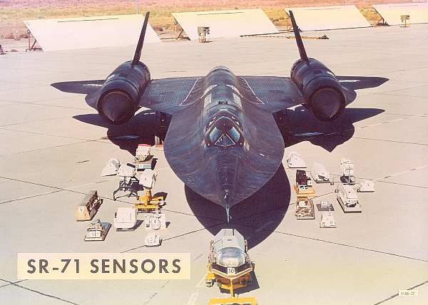
The SR-71 Blackbird carried a wide variety of cameras and sensors. The Sensors fall into three basic groups; Optical, Radar, and Elint . There were on-going modifications and updates to the sensors as capabilities improved and camera resolutions increased. There was initially an Infrared system also installed for several years at the beginning of the operational missions but it was discarded around 1970. It should be noted that many of these sensors were unique to only the SR-71; having to fit inside the dimensions of the mission bays. In almost all instances Technical Representatives of the respective sensors were on hand at Beale AFB in California to provide expertise on their equipment and resolve problem areas. The Sensor systems are individually divided up to represent their function. This is page One of Three pages. Links to each of the pages is found at the bottom of each respective web page.
(Sensor Layout photo below circa 1974)
The
nose shown in the photo is what was called a "PIP" or ballast nose.
I don't remember the acronym, but later obc/radar noses all had radome
blisters on the chine 20 cm or so behind the pitot tube for the DEF A series
systems. We could change a nose from either ballast or OBC to SLR in about 2
hours or less if everything went smoothly. They were held on by 4 clevis bolts,
the most time consuming part of the change was getting the right latch tension,
it was measured by feel when you closed the latch, "yea, that was tight
enough", or too loose, pull the nose and change the clevis".
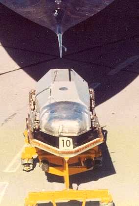
Optical Bar Camera (OBC)
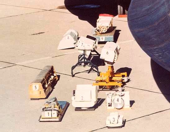
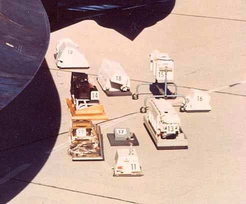
Item Identification:
Here is our attempt to identify the above Lockheed Photo with the correct items. As time goes on and members of the SR-71 Blackbird family view this web page, each item may be correctly identified and marked accordingly. If you have a correction or addition, please email Leland at:
1. IR (Infrared) Camera. The IR system was designed and manufactured by HRB-Singer of State College, PA not the Singer Sewing machine Co . The IR camera was located in M Bay. Discontinued in the early 1970's.
2. The TROC camera was a low-resolution camera used mainly for track verification. Manufactured by Fairchild.
3.
4.
5.EMR (?)
6.SLR (Side Looking Radar) Recorder.
7.
8.Operational Objective Camera - (OOC) Manufacture: ITEK.
9.
10.Optical Bar Camera (OBC). The OBC started out as 24", and was later redesigned to 30". OBC Lineage: ITEK to Goodrich.
11.DEF A system.
12.
13.DEF F System, predecessor of the DEF H.
14.EMR (?)
15.
16.
17.DEF C system.
18.
19.Operational Objective Camera (OOC). Manufacture ITEK.

SR-71 Payload Configuration


Terrain Objective Camera (TROC)
The TROC was made by Fairchild. 6 inch focal length lens with 9 inch wide film. The TROC was a mapping camera located in the bay just forward of the nose gear, you had to disconnect the gear doors just to install the unit.
The Terrain Objective Camera did not have a high resolution, and I want to recall it was 25 feet. We were always told it's primary purpose was flight tracking so that if a country accused us of an over flight, the TROC take would prove or disprove exactly where we flew. Threading the needle in the Gulf of Tonkin and rolling out on a NW heading for the Haiphong - Hanoi slot without over flying China's Hainan Island was an example. Thus, the TROC was turned on shortly after T/O and not turned off until final S/D at a mission's end.

TROC Camera
(Photo courtesy Tony Landis-Lockheed Martin)
Operational Objective Camera (OOC)
Manufacturer: ITEK
Operational Objective Camera - (OOC) Manufacture: ITEK. The OOC was made in the Boston division of ITEK, replaced by the OBC. ITEK was originally an Italian manufacturer of eyeglasses and frames. The OOCs were panoramic cameras with a 13 inch focal length using 70 mm wide film. Both Right and Left had their views fixed with respect to the vertical and scanned horizontally from -5 degrees below the aircraft nadir out to +45 degrees on their respective sides. Both right and left OOC's had their views fixed with respect to the vertical and they scanned horizontally from -5 degrees below the aircraft nadir out to +45 degrees on their respective sides. The cameras were able to set their framing rates so at the current ground speed (from the Nav system) each photo would overlap the area covered by the previous photo by 55%. That is what provided the ability of the PI's to obtain Stereo views from the OOC photos. The OOC's were discontinued in the early 1970's.

Nomenclature: TEOC: Technical Objective Camera/ OBC: Optical Bar Camera
(Photo Courtesy Dave Nolte, Boeing)
During the early part of the program (Mid-1960's) they used four different sensor, a Fairchild Terrain Objective Camera (TROC), a mapping camera located in the bay just forward of the nose gear, you had to disconnect the gear doors just to install the thing. An Infrared camera located in M Bay designed and manufactured by HRB-Singer of State College, PA. It was discontinued in the early 1970's. I think, two Itek OOC's, and two Hycon TEOC's. The TROC and the infra red camera went away while I was in Thailand, when I got back they had just gotten the OBC's.
Technical Objective Camera (TEOC)
Manufacturer: HYCON
Manufacturer's lineage for the TEOC was Hycon to Actron to McDonald-Douglas to Boeing.
Very High Resolution Photography of designated areas
Programmable system with a 48 inch focal length. The TEOC resolution was 110 lines per millimeter, which equates to about 6" ground resolution from an operational altitude. The TEOC's were mounted both sides of Chine controlled by a computer – 100s of targets/mission with sub 12” possible – out to 20 nm on side mounted.

TEOC Camera
(Photo courtesy Tony Landis-Lockheed Martin)

The TEOC's resolution was indeed capable of 6 inch resolution. I have a print of a TEOC shot, looking straight down at Edwards AFB and taken from one of the Test Force birds at mach 3.0 to 3.2 and at about 81,000 feet. Visible to the eye on the print are the diagonal lines in parking lots on base with cars and empty slots clear. The lines look like feathers painted on the ground and when you put a simple magnifying glass to them you see the parking lot purposes of these feathers......4, 5, 6 inches wide (?) dividing lines between parking spots. And this from a print! At Beale, I've watched the PI's use the original negatives on projectors that would blow-up views by many powers and then you would see amazing details. I can't tell you the exact date of the picture, but it also captures both B-70's on the ground which marks it before June 8, 1966, the day of the B-70 loss after it's midair with an F-104. I also want to recall a Beale story, where one of our birds made the same run over Edwards, westbound, where after coasting out, the route would turn north and follow off-shore up the California coast for SLR coverage of SFO ( I flew this mission a couple of times ). On this particular mission, the TEOC was left on, looking straight down, but when the bird made a 30 degree bank to the right it moved it's viewing spot out to sea and towards the ocean horizon. Our PI's, spotted a ship and were able to identify it as a USN Destroyer at a slant range of about 94 nm away. We were always impressed with this Intel claimed story, since it showed us what satellite cameras could do from Space. I "think" I saw this Destroyer blow-up picture once on a visit in the Sage building Recce-Tech area ( where we animal crew members were not often allowed to go ). (Information courtesy Colonel David Dempster, RSO, USAF (Ret)

Edwards AFB @ 81,000 Feet. SR-71 with nose removed.
Original print is much sharper...to the extent that the parking lot lines in the right of the photo are distinct.
(Photo Courtesy Colonel David Dempster, RSO, USAF (Ret)


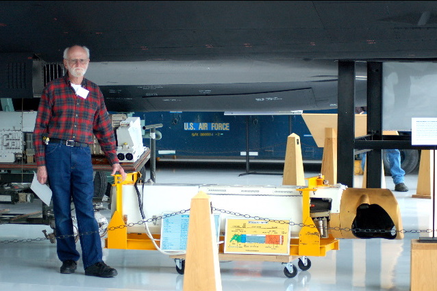
Russell Harvey
. Retired USAF M/Sgt from the Photo Shop at Beale AFB in California. The Camera is a HR-308B [ TEOC].
Taken at Evergreen Aviation Museum in McMinnville, Oregon.


TEOC Cameras recovered from the South China Sea. SR-71 #974 - April 21, 1989 (Ichi Ban). Last SR-71 to crash. Left engine bearing seized and the jet crashed off the coast of Luzon, Philippines.
Crew members Dan House and Blair Bozak safely ejected.
Optical Bar Camera (OBC)
Manufacture: ITEK then Goodrich
High Resolution Panoramic Photography
(Detachable Nose Component)
The OBC could photograph 100,000 square miles of the Earth's surface per hour. Film image 72 miles wide, & film length 10,500ft.
Initially a 24 Inch focal length lens; later extended to 30 inch focal length . Both cameras (OBC and TEOC) provided superb detailed high resolution photographic images horizon to horizon.

OBC Camera
(Photo courtesy Tony Landis-Lockheed Martin)


Go to SR-71 Sensor Web page #2....Radar Imagery
Go to SR-71 Sensor Web page #3...ELINT (Electronic Intelligence)
| SR-71 Front Page | Links Page | Index Page | Recollections | 2001 Reunion |
| "SR-71 Blackbirds" Web Site Navigator | ||||
| First Created: April 15, 1996 - Last Revised: August 18, 2007 | ||||
| Copyright © 1996 Leland R. Haynes Email: sr71webmaster@sr71.us | ||||
Credits: Mike Hull, Donn A. Byrnes; Russell Harvey, Robbie, David Nolte, Bill Whittle, Jim Fitzgerald, David Dempster, Buz Carpenter, Pima Air Museum, Evergreen Aviation Museum; Don Stein. Tony Landis, Lockheed Martin Corporation
Page #220 of the SR-71 Blackbirds